Locating a Remote Property
by Andreas Paramonoff
Doing a personal inspection of a piece of land you are considering to purchase is an essential part of your due diligence. Stepping onto a piece of property in person lets you know exactly what you are getting from the topography to the views and the tree cover. It also lets you know the infrastructure such as roads and power.
These are the steps to quickly and efficiently locate a rural piece of property, even one that might be very remote. Inadequate preparation will result in much time wasted and not locating the property.
This guide is intended primarily for the West. Some Eastern states and Texas use different map coordinates than those described here.
Plat Map
The search starts with the Plat Map. The plat map is the detailed survey map made when the land was subdivided. The plat map may be a named subdivision or a part of a section which contains the subdivided property.
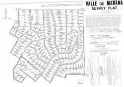
There are several ways in which you can get the plat map for the property. First, many sellers provide a plat map on closing. Another way to get a plat map is from an online site which has detailed subdivision information such as http://ruralterra.com. Finally, the plat map can be acquired from the county clerk, also sometimes referred to as the county recorder. If you live near the property then you can purchase a copy from the county clerk in person, but if you are farther away then you can call the county clerk and send a check for a copy of the plat map.
Once you have the plat map then you can start locating your subdivision. All plat maps have the coordinates of the subdivision, usually in township coordinates.
If there are no coordinates on the plat map then you have an incomplete copy of the plat map or composite map. Get a complete plat map from the county.
You also need to locate the lot on the plat map. If the plat map is from the seller then it is probably marked. If not the use the lot numbers which are marked on the plat map. If you have an assessor map rather than a plat map then there can be a confusion because both the lot number of the assessor parcel number (or the last part of it) are also on the lots. The legend on the assessor maps should indicate which is which.
Locating the Subdivision Online
You can now locate the subdivision online. To do this from township coordinates, you need the Meridian, the Township, the Range and the Section from the plat map. The Range is designated with an R and it will have an E for East or W for West. The Township with a T and it will have an N for North or S for South.
For this example, the plat map has: New Mexico Principal Meridian, T8N, R13W, Section 16. These coordinates are:
-
Meridian: New Mexico
-
Township: 8 North
-
Range: 13 West
Some plat maps may not have the Meridian. Since Meridians cover large areas it should be possible to determine which one your subdivision is in if you know the state and county. This map can be used to determine the Meridian:
http://www.csuchico.edu/lbib/maps/us_map.html
This link will convert the township coordinates into GPS coordinates:
http://www.esg.montana.edu/gl/trs-data.html
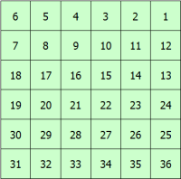
The GPS coordinates can be used to find the exact location of the subdivision on a map. The above link allows switching to terra server with those coordinates. If you are using terra server (terraserver-usa.com) the I suggest switching to the topo map format to make zooming in on your section easier. In topo map format each red square is a section and some of them have the section number on it. Sections are numbered as follows.
As a confirmation that the subdivision has been correctly located, the roads should be visible in your mapping tool and they should match with roads on your plat map as in the following examples:
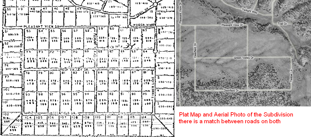
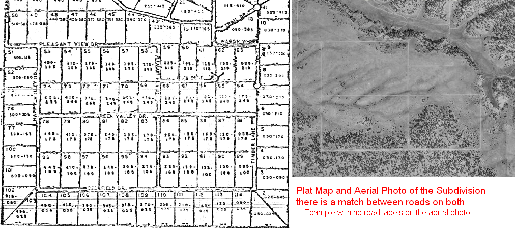
Print out copies of the map, one road map, one aerial photo and one topographical map. Google maps or Microsoft Local Live are good for producing these maps.
Example. Use the above information to get the location of the lot in the plat map
- Plat map, lot xxx <link>
-
The township coordinates from the map are:
-
This converts to GPS coordinates:
- Terra Server link to the section <link>
- The lot in Google maps <link>
Locating the Subdivision on a Paper Map
Get a BLM map of the area of the subdivision. If you know only the county and state then you may need to purchase several maps. They can be purchased at the BLM field offices. These can be found at:
The top and bottom edges of the maps shows the Ranges and the right and left edges show the Townships. The intersection of your Range and Township gives you your township, 36 square miles. The section number on the plat map can be used to locate the individual section. This is where the subdivision is.
Coming soon - example show locating a township on a BLM map.
Other maps such as forestry service maps can be used instead of BLM maps, in particular if BLM maps are difficult to obtain.
Purchasing a BLM map or equivalent of the area is also helpful because a GPS can be used to locate yourself on the BLM map.
Map Tools
Besides the area and plat maps, the most important item to take along is a compass. The maps are not much use if you don’t know which direction you are driving. The compass can be used to orient your maps, triangulate to find your location and to help find the older and overgrown roads. How to use a compass goes beyond the scope of this article, but some training will be very helpful. For example:
http://geology.isu.edu/geostac/Field_Exercise/topomaps/self_finding.htm
A GPS can also be very useful. It can be used to pinpoint you location on a map with the UTM or longitude and latitude coordinates. It can also be used record your location so that you can find your way back. Some sellers provide GPS coordinates of their lots and for driving directions. I strongly suggest practicing with your GPS before using to locate a lot.
A link for using GPS devices:
http://www.interment.net/column/records/gps/
A link on getting GPS coordinates from Google maps.
http://earth.google.com/userguide/v4/ug_gps.html
Research the Roads
With area maps to help you find the subdivision and a plat map that helps you find your lot within the subdivision you need to make sure that you can use the roads to the subdivision.
Check for legal access on the access roads. There is nothing like making a long trip and finding a gate at the start of the access road. The seller should be able to provide you with the legal access. If they cannot then the county should have a road inventory map.
It is alo helpful to determine the condition of the road. If it is an old unmaintained subdivision then a 4WD is probably needed. If there are no maintenance fees and no one living in the subdivision (see the aerial photos) then the roads are probably in poor condition.
If it is a remote subdivision with very few people using it then it might be gated and locked. Even though owners in the subdivision or local ranchers have no right to lock the subdivision they might do so if no one has visited in years.
Go!
Now the fun part starts. Use the area map to find the subdivision. The access roads may not be marked and there may be other roads that add to the confusion. Carefully measuring distances, making the correct turns and keeping track of landmarks is essential.
The entrance to the subdivision may not be marked. If the mileage from your area map indicates that you should have entered the subdivision and there is no entrance sign then it is necessary to determine your exact location on your map, preferably a BLM map. The best way to determine your exact location is by GPS or triangulation with a compass. See the Map Tools section above for details. From your exact location you should be able to determine the start of the subdivision start.
You have made it to the subdivision!
The plat map is now essential to locating your exact lot. If it is a newer or well maintained subdivision then it is a simple matter of following the roads to your lot. However, if the lot is within an older subdivision or an unmaintained subdivision then finding the lot can be a challenge. Expect these problems:
-
there might not be any street signs
-
the roads may be overgrown and hard to see since they might not have been maintained for decades. Extra careful attention must be used to find and follow these roads.
-
the roads currently in use may be non-platted roads such as roads made by local ranchers. They are not necessarily placed where the plat maps indicate.
-
the roads indicated on the plat maps may never have been constructed by the developer
-
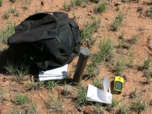
survey pins were probably put in when the property was subdivided, but they may no longer exist or they may be hard to find
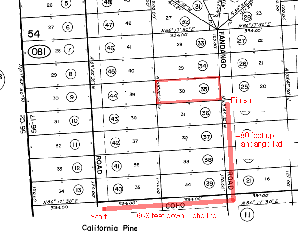
Assuming you know exactly where you are on the BLM map (see above) you can tell where you are on the plat map from the mapping discussions above. These are some steps to find your lot using the plat map.
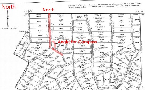
The compass to give you the direction of the roads to follow. The direction can be taking from the plat map since the plat map indicates North. This is an example of a compass bearing from a plat map:
The distance to the intersections and to your can be determined since the lots all have their sizes marked on the plat map.
Now pace, use a long measuring tape or use a GPS to measure the distance traveled on the roads and use the compass to ensure you remain on the road system. Follow the road system to you lot.
The side roads and survey markers should provide clues as to exactly where you are. Remember to follow your compass and not the current roads. If your compass indicates that the road is not going in the correct direction then look for evidence of a very old road where your compass is pointing. This is a ranch road which is not platted:
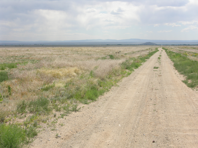
Since the platted roads (that means roads on the plat map) may not have been improved in decades or the smaller secondary platted roads may never have been built. These are some examples of the types of roads you may encounter:
-
example 1 a platted road in good condition
-
example 2 a road not graded in decades
-
example 3 overgrown road seen from the ground and from an aerial photo
-
example 4 old road seen from the ground and from a plat map
-
example 5 old road where the grading is still visible
-
example 6 old road where the gap in the bushes can some blading can be seen
Large subdivisions pose an additional challenge since they may be too large to find your lot in on foot. It is best to use your GPS or triangulation to find some location within the subdivision close to your lot and find your lot from there. A natural choice is a section boundary in the subdivision since that gives you the exact distance to your lot.
If the seller provided GPS coordinates or you have a tool to get GPS coordinates for your lot then you can get the direction and distance to the lot from the GPS and you can use compass to march directly to the lot. Remember to set the GPS to give the angle in magnetic north.
Congratulations, you have found your lot!

